The snowfall on February 9th at La Palma and Tenerife seen by GPS-GLONASS receivers
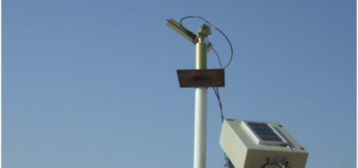
 The Izaña Atmospheric Research Center (IARC) evaluates, with scientific purposes, the atmospheric water content from a local network of GPS-GLONASS located at several sites at La Palma and Tenerife islands since July 2008.
The near real time monitoring of the daily evolution of the total column water vapour content, that theoretically could precipitate on the population under some specific conditions, could be interesting for some meteorological activities.
As an example, we report atmospheric total column water vapour evaluated from GPS-GLONASS stations located at Roque de Los Muchachos, in La Palma, and at the Izaña Atmospheric Observatory, in Tenerife, during the snowfall took place in summits of these islands on February 9th, 2011.

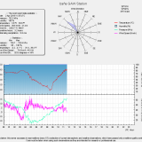
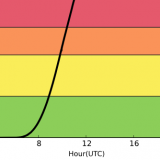
By visual observations done in both stations, we know that the first snowfall started at the Roque de los Muchachos between 10:00 UTC and 10:30 UTC, approximately, and later, at Izaña, at aorund 15:00 UTC. As it can be seen in the previous graph, two hours before the snowfall at Roque de los Muchachos started, a noticeable increase of total column water content is observed. The maximum precipitable water is recorded at around 12:00 UTC, so an increase of 6 mm took place in four hours (since 8:00 UTC), so a ratio of 1.5mm/h. This increase is appreciated first at Roque de los Muchachos since the front moves from west to east, as it can be confirmed by the Meteosat and the radar reflectivity combined images.
Error
A 15-minute animated frames video in grey-scale from Meteosat 9 (MSG-2) channel 12 (high resolution visible channel), normalized during sun light period, and replaced by channel 9 (infrared 10.8µ) during the night period, is shown. Superimposed colour-scale PPI of normal reflectivity (DBZ) from the Meteorological radar at the Canary Islands (located in Gran Canaria Island) is also depicted. In red, the atmospheric discharges detected by the AEMET network in the 15-minute period after each satellite image. Positive discharges are plotted with ”+” and negative ones with “-“. Notice that radar reflectivity images show some shadow areas caused by the sharp orography of the islands, specially those produced by the Teide volcano (in Tenerife) over La Palma what results in some lack of precipitation band echoes over this island.
Three hours later, the same increase in total water content (6mm and an averaged ratio of 1.5mm/h) is observed from 11:00 UTC to 15:00 UTC at Izaña Observatory.
Concerning the coastal stations (Santa Cruz de Tenerife and Los Cristianos) we have also observed the influence of the front in the precipitable water provided by the GPS-GLONASS receivers.

At Los Cristianos station a progressive increase of 1mm/h in the column water vapour content is observed in the morning (from 5 to 14 UTC). Nevertheless, the arrival of the “hard core” of the front seems to occur from 14 UTC to 16 UTC, when the observed ratio is twice, exceeding 2mm/h. At Santa Cruz de Tenerife station, from 5 UTC to 11:00 UTC the precipitable water growing ratio is moderate (1mm/h). Between 11 UTC and 15 UTC this ratio doubled, with 2mm/h. The total precipitation observed at Santa Cruz de Tenerife and Los Cristianos was 5.6 and 4.7 l/m2, respectively.