ACTRIS
ACTRIS (Aerosol, Clouds and Trace Gases Research Infrastructure) is a pan-European initiative consolidating actions amongst European partners producing high-quality observations of aerosols, clouds and trace gases. Different atmospheric processes are increasingly in the focus of many societal and environmental challenges, such as air quality, health, sustainability and climate change. ACTRIS aims to contribute in the resolving of such challenges by providing a platform for researchers to combine their efforts more effectively, and by providing observational data of aerosols, clouds and trace gases openly to anyone who might want to use them.
During 2015-2019 the coordination of ACTRIS has been supported by two different EC-projects; ACTRIS-2 and ACTRIS Preparatory Phase Project (PPP). The former revolved around on-going research, coordinating efforts of partner organisations and producing observations and data, while the latter is a project aiming to establish a research infrastructure with its own legal entity and operational structure that will carry on the work done by ACTRIS-2.
Regional Brewer Calibration Center for Europe (RBCC-E)
In November 2003 the WMO/GAW Regional Brewer Calibration Center for Europe (RA-VI region) (RBCC-E) was established at IZO. The RBCC-E reference is based on three double Mark-III Brewer spectrophotometers (the IZO triad): a Regional Primary Reference (Brewer 157), a Regional Secondary Reference (Brewer 183) and a Regional Travelling Reference (Brewer 185) .IZO is located in a subtropical region (28oN) on a mountain plateau (2373 m a.s.l.) with pristine skies and low ozone variability. This location allows routine absolute calibrations of the references in similar conditions to the Mauna Loa Observatory (MLO), Hawaii, USA. The establishment of the RBCC-E Triad allows the implementation of a self-sufficient European Brewer calibration system that respects the world scale but works as an independent GAW infrastructure.

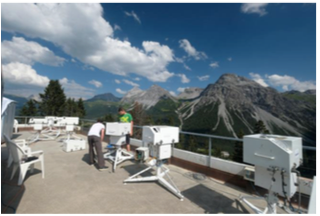
The RBCC-E travelling reference Brewer #185 at the Arosa 2018 campaign
There are two European Calibration Centers for the two types of ozone spectrophotometers in use: Dobson and Brewer. The Regional Dobson Calibration Center for Europe (RDCC-E) is located at the Meteorological Observatory Hohenpeissenberg (Germany). Since 2009, the RBCC-E activities have largely been funded by the ESA project, “CEOS Intercalibration of Ground-Based Spectrometers and Lidars” which includes the participation of the two European Calibration Centers (RBCC-E and RDCC-E).
Objectives
The main objectives of this Cooperation programme are:
- To implement a system for routine absolute calibrations of the European Brewe r regional reference instruments at IZO, fully compatible with absolute calibrations of the world reference triad at MLO.
- To perform periodical calibration campaigns using the Regional Primary Reference B157 (during intercomparisons held at IZO) and the Regional Travelling Reference B185 spectrophotometer (traceable to B157) in continental campaigns.
- To perform regular comparisons of the Regional Brewer Primary Reference B157 with the Regional Dobson Reference D074 to monitor the relationship between both calibration scales in the RA-VI region.
To study the sources of errors of the absolute calibrations and to determine the accuracy of total ozone measurement achievable by the Brewer spectrophotometer under different atmospheric conditions or instrumental characteristics.
Tasks
- The main tasks of this Cooperation programme are:
- To develop quality control procedures and Standard operating Procedures (SOPs) for traceability of measurements to the reference standards.
- To maintain laboratory and transfer standards that are traceable to the reference standards.
- To perform regular calibrations and audits at GAW sites.
- To provide, in cooperation with Quality Assurance/Science Activity Centres, training and technical assistance for stations.
Sand and Dust Storm Centres
The IARC is actively involved in the strategic planning of activities, scientific advice on aerosols and dust observation, as well as in initiatives on capacity building and training of two Centers dedicated to Sand and Dust Storm activities: 1) the WMO Sand and Dust Storm Warning Advisory and Assessment System (SDS-WAS) Regional Center for Northern Africa, Middle East and Europe, and 2) the Barcelona Dust Forecast Centre (BDFC).
WMO Sand and Dust Storm Warning Advisory and Assessment System (SDS- WAS) Regional Center
The Sand and Dust Storm Warning Advisory and Assessment System (SDS-WAS) is a programme of the World Meteorological Organization with the mission to enhance the ability of countries to deliver timely and qualitative information related to sand and dust storm forecasts, observations to end users, and improve the knowledge of this phenomena.
The Regional Centre for Northern Africa, Middle East and Europe (NA-ME-E) was established in 2007 to coordinate SDS-WAS activities within this region. The Centre, as a consortium of the Spanish State Meteorological Agency (AEMET) and the Barcelona Supercomputing Centre – National Supercomputing Centre (BSC-CNS), soon evolved into a structure that hosted international and interdisciplinary research cooperation between numerous organizations in the region and beyond, including national meteorological services, environmental agencies, research groups and international organizations.
SDS-WAS Regional contributions
IARC and AEMET contribute to the scientific activities of the SDS-WAS Northern Africa, Middle East and Europe Regional Centre through various multidisciplinary studies.
IARC led a study entitled “The pulsating nature of large- scale Saharan dust transport as a result of interplays between mid-latitude Rossby waves and the North African Dipole Intensity” (Cuevas et al., 2017).
The main objective of this study was to explain the atmospheric processes behind the intra-seasonal variations of dust outflows towards the Mediterranean and the subtropical North Atlantic Ocean. Daily and monthly data of MODIS Aerosol Optical Depth MODIS aerosols, NCEP/ NCAR reanalysis, ECMWF reanalysis, and MACC reanalysis (today CAMS) were used.
SDS-WAS and Copernicus CAMS-84 Service
The Copernicus programme, previously known as GMES (Global Monitoring for Environment and Security), consists of a complex set of systems, which collect data from multiple sources: earth observation satellites and in situ sensors such as ground stations, airborne and sea-borne sensors. It processes these data and provides users with reliable and up-to-date information through a set of services related to environmental and security issues.
CAMS-84 is a global and regional a posteriori validation activity, with focus on the Arctic and Mediterranean areas. The SDS-WAS Regional Centre, through BSC-CNS as the main parter and AEMET as a third-party, participates in CAMS-84 providing validations and evaluation of dust and aerosols products.
The Barcelona Dust Forecast Centre
In May 2013, in view of the demand of many national meteorological services and the good results obtained by the SDS-WAS related to operationalization, the 65th Session of the WMO Executive Council designated the consortium formed by AEMET and the BSC-CNS to create in Barcelona the first Regional Specialized Meteorological Centre with activity specialization on Atmospheric Sand and Dust Forecast (RSMC-ASDF). The Centre operationally generates and distributes predictions for Northern Africa (north of equator), Middle East and Europe.
Change of technical director of the two WMO regional dust Centres
In 2018 and part of 2017 a careful and prolonged work of transfer of know-how was carried out to ensure the smooth change of technical director of the two centres. Enric Tarradellas (AEMET) retired in April 2019, and Ernest Werner (AEMET) took over the position of technical director. The magnificent work carried out during all these years by Enric to establish first, and then consolidate the two regional dust centres of the World Meteorological Organization, deserves all our sincere praise and thanks. It has been a pleasure to collaborate with him and count on his enthusiasm and determination. Our best wishes for Enric in his new life, we will miss him greatly. The technical direction of the SDS-WAS Regional center NA-ME-E and the Barcelona Dust Forecast Centre will be exercised with no less enthusiasm and dedication by Ernest from 2019, to which we will give all our support from the IARC.
GAW Tamanrasset twinning programme
In 2006, the “GAW-Twinning” between IZO and Tamanrasset GAW stations was initiated with the Saharan Air Layer Air Mass characterization (SALAM) project. This was part of a cooperation programme between the l’Office Nationale de la Météorologie (ONM, Algeria) and AEMET. In September 2006, the AERONET Tamanrasset-AEMET Cimel station was installed.

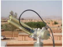
The AERONET Cimel at Tamanrasset on the terrace of the Regional Meteorological Centre
WMO CIMO Testbed for Aerosols and Water Vapour Remote Sensing Instruments
The mission of the Commission for Instruments and Methods of Observations (CIMO) is to promote and facilitate international standardisation and compatibility of instruments and methods of observations used by Members, in particular within the WMO Global Observing System, to improve quality of products and services delivered to/by Members and to meet their requirements.
Main objectives and activities of the Izaña Testbed
The main ongoing activities of the Izaña Atmospheric Observatory Testbed are related to instrument validation, development of new methodologies and devices for aerosol observations.
Products obtained at the Izaña Atmospheric Observatory from EKO spectral direct irradiance measurements
The Izaña Observatory acquired an EKO MS-711 spectroradiometer in 2016, it began to measure continuously in March 2017. This spectroradiometer is designed to measure the global solar spectrum, although EKO Instruments designed a collimator tube that allows measurements to be made of Direct Normal Irradiance (DNI) (for more information see Section 10.2). From the measurements of DNI we have obtained AOD, water vapour and direct radiation between March 2017 and December 2018.

View of the radiation/aerosol instruments on the IZO instrument terrace (Photo: C. Bayo).
The reconstruction of a 77-year time series of AOD at 500 nm by using artificial neural networks
The reconstruction of a 77-year time series of AOD at 500 nm at IZO has been achieved by using artificial neural networks (ANNs) from 1941 to 2001 and AOD measurements from AERONET (Cimel photometer) between 2003 and 2017.
The ANN method has proved to be a very useful tool for the reconstruction of daily AOD values at 500 nm from meteorological input data, such as the horizontal visibility, fraction of clear sky, and relative humidity, recorded at IZO. This methodology could be extrapolated to other sites, especially those affected by high dust loads.

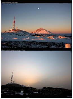
Contrasting atmospheric conditions covering a broad range of aerosols burden make Izaña Atmospheric Observatory a key site for aerosol remote sensing instruments testing and calibration: pristine conditions (upper panel) and significant dust load (lower panel) (Courtesy of S. Rodríguez).
Lunar Photometry
The Lunar Photometer research group, established in 2011 between Cimel Electronique and the Izaña Atmospheric Research Center, is focused on the design and implementation of new strategies to tackle the problems to monitor atmospheric aerosols and water vapor content at night. The most important obstacles to overcome are the low incoming energy from the Moon, the variation of the Moon’s illumination inherent to the lunar cycle, as well as the non-lambertian reflectance properties of this celestial body.
In this regard, the Lunar-Langley Method (Barreto et al., 2013a) has emerged as a useful tool to perform an accurate calibration of lunar photometers, and the CE318-U prototype was developed as an instrument capable to obtain aerosol optical depth (AOD) and precipitable water vapor (PWV) with similar accuracy to daytime measurements. Further efforts led to the development of the first sun-sky- lunar photometer (trade name CE318-T) in 2014. This new instrument is able to perform daytime and nighttime photometric measurements using both the Sun and the Moon as light source, allowing the extraction of a complete diurnal cycle of aerosol properities and water vapor content, valuable to enhance atmospheric monitoring.
IARC CE318-T observations started in 2014, with three prototypes installed at IZO: one reference instrument and two secondaries. The reference, assumed as CE318-T master, is currently working as IZO master. The two CE318- T secondaries were used to develop and check new procedures to transfer the absolute Lunar Langley calibration technique to field instruments. The information extracted from these three years of CE318-T observations has allowed the comprehensive assessment of the CE318-T performance, and in addition, has served to identify other sources of problems related to lunar photometry.
As a result of this analysis, the AERONET team accepted this new Cimel version henceforth in AERONET, once the homogeneity of the network was ensured, suggesting the replacement of CE318-N instruments by the new CE318-T as far as possible (see the news published on 2 Oct. 2016, on the AERONET webpage).
Assessment of nocturnal Aerosol Optical Depth from lunar photometry
Moon photometry has arisen as a useful tool for a daily and continuous aerosol monitoring, especially at high latitudes. A precise Moon irradiance model is mandatory in lunar photometry, to take the continuous change of Moon’s brightness over the cycle into account. The RObotic Lunar Observatory (ROLO) model, published by Kieffer and Stone (2005 is considered an essential tool for Moon photometry. However, very limited studies exist in the literature focused on the application of this model to night- time data as well as to study the model contribution to the aerosol optical depth (AOD) uncertainty.
Lunar Photometry Campaign and Workshop Izaña 2017
On 1-17 June 2017, a Lunar Photometric Campaign was hosted at the Izaña Atmospheric Observatory. In addition, on 7-8 June 2017, a workshop on the same theme was held at IZO. These events were organized by the Izaña Atmospheric Research Center and the Atmospheric Optics138 Izaña
ESA project: lunar spectral irradiance measurement and modelling for absolute calibration of Earth Orbiting optical sensors
The ROLO model has been found to be the most reliable extraterrestrial lunar irradiance model so far. However, some comparison exercises have proven that the ROLO model has an uncertainty in the absolute scale of 5-10 %, which might be related to the absolute calibration of the model derived from observations of the star Vega. There is another possible source of errors related to the atmospheric extinction correction. The different zenith angle for the Moon and Vega during this star-based calibration method leads to lunar reflectance spectra with unexpected band-to- band deviations, introducing the spectral (absolute) band scalings.
The conclusion of previous works is that the uncertainty of the ROLO model for absolute spectral irradiance is poorer (5-10%) than for relative spectral irradiance (≈1%). The long-term aim should be to provide SI-traceable absolute irradiance for the Moon.
Design, development and testing of a new low-cost and robust zenith-looking multi narrow-band radiometer for AOD and water vapor retrieval.
A look-up table (LUT) methodology for AOD retrieval from zenith sky radiance has been developed and applied to AERONET Cimel sunphotometers from Santa Cruz de Tenerife, Izaña and Tamanrasset (Algeria) validating the results against AERONET AOD. The LUT was optimised for mineral dust aerosols. The methodology has been applied to a new low-cost and robust zenith-looking multi narrow-band radiometer developed in collaboration with SIELTEC S.L. company. Estimated AOD with the new prototypes demonstrated good results when validated against reference AOD from AERONET
Validation of AOD in UV range using double Brewer spectrophotometers.
A new AOD product in the UV range has been developed and assessed using the Izaña Testbed facilities and ancillary data. In this project the AOD algorithm applied to instruments of the European Brewer Network has been implemented. This network is comprised of close to 50 Brewer spectrophotometers, mostly located in Europe and adjacent areas, although instruments operating in, for example, South America and Australia are also members. Using data from the Brewer intercomparison campaigns plus comparisons with Cimel sun photometers and UVPFR instruments, the precision, stability, and uncertainty of the Brewer AOD in the ultraviolet range from 300 to 320 nm was determined. Our results show a precision better than 0.01, an uncertainty of less than 0.05, and, for well- maintained instruments, a stability similar to that of the ozone measurements.
Low-cost hand-held sunphotometer assessment
TENUM is a French company that has designed and manufactured a small educational sun-photometer named Calitoo. This instrument has been developed under the scientific and technical supervision of Dr. Phillipe Goloub and Eng. Luc Blarel from LOA (CNRS-University of Lille). Calitoo sun-photometers are used in the Global Learning and Observations to Benefit the Environment (GLOBE) program, which is a worldwide hands-on, primary and secondary school-based science and education program.

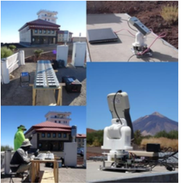
Top left and right, Calitoo sun photometer calibration campaigns in 2017 and 2018 at Izaña Atmospheric Observatory. TENUM Calitoo activities at IARC: preparations and measurements for Langley calibration performed by Frederic Bouchar and Stéphane Villeneuve (bottom left) and Calibot tests (bottom right) (images courtesy of TENUM).
Potential use of low-cost hand-held sunphotometers for operational activities
Currently, five Calitoo sun-photometers are used in experimental campaigns promoted by IARC. The objective is to provide a comprehensive assessment of the potential use of the very low-cost Calitoo-TENUM hand-held sun- photometer for operational dust model and satellite observation validation activities within the WMO SDS- WAS.
1) Since February 2017, a Calitoo has been taking measurements in the heart of the Sahara Desert at the Tamanrasset World Meteorological Organization – Global Atmospheric Watch (GAW) station (Algeria) (see Section 20).
2) Two Calitoos are currently being used in Iran in a pilot project in collaboration with the Islamic Republic of Iran Meteorological Organization (IRIMO). One in the urban Tehran megacity station since November 2016 to monitor aerosol pollution and the impact of dust outbreaks on the city. Another one has been taking measurements in the Mt. Aminabad (Firoozkoh) regional GAW station since January 2018.
3) Since March 2018, a Calitoo has been operating on board the oceanographic vessel “ ngeles Alvari o” from the Spanish Institute of Oceanography (IEO). This Calitoo is taking maritime measurements in the Atlantic Ocean, from Canary Islands to Galicia, as well as in the Mediterranean Sea, from Cataluña to Andalucía.
4) An additional Calitoo is currently operating in the AEMET facilities in Gran Canaria for testing its feasibility for operational issues in weather observations and forecasting. This experience might be extended to meteorological observatories of many airports in North Africa in the future to provide additional information in Synop and METAR observations for dust model evaluation and data assimilation.
Development of synergy photometer/lidar methodologies for retrieving vertical aerosol extinction.
The Fernald-Klett method is commonly used to derive aerosol optical properties profiles from elastic lidars together with AOD measurements from a collocated photometer. This method assumes a range independent lidar ratio, which involves an aerosol vertical distribution with range invariant physico-chemical properties. However this approximation may be unrealistic when we find different aerosol types at different heights. This situation can be improved with additional measurements and previous knowledge about the aerosol vertical distribution.
We analyzed a decade of lidar and photometric data at two heights from the observatories of IZO and SCO. This region is characterized by a quasi-permanent thermal inversion which separates the troposphere into two layers: the marine boundary layer and the free troposphere. As a result, two layers with different lidar ratios have been considered in this study (Two-layer method).
Our results suggest the suitability of the Two-layer method to estimate aerosol backscatttering and extinction profiles βaer(r) and σaer(r), respectively, in those situations where different aerosol layers exist in the vertical. The lidar ratio obtained by means of the Two-layer method was also validated with the value derived independently from the sun/sky photometer 15 at IZO, with a good agreement between the two techniques .
