The arrival of autumn coincides with intense precipitations in Izaña
Last Wednesday September 22, the autumn started at 04:09 local time. The change of season was accompanied with an episode of precipitations in the whole Tenerife Island. Rains also affected other islands of the archipelago, mainly the western ones. The atmospheric circulation in our region was driven by the presence of an elongated trough at mean levels, in process to isolate a low from the general circulation, located to the west of the Canary Islands. This meteorological scenario induced a strong SW circulation which converged with the circulation of the African high resulting in a dynamic forcing and a strong tropical humidity advection over the Canary Islands.

Figure 1; Geopotential height at 500 hPa on September 22 at 12 UTC: a strong SW flow is observed over the Canary Islands.
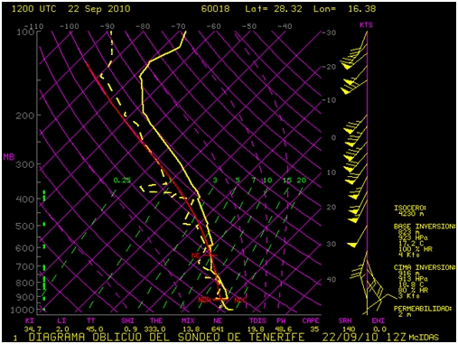
Figure 2; Rawinsonde from Tenerife (Güímar 60018 station) on September 22 at 12 UTC. A strong humidity advection is observed in mean and low levels.
The precipitations began in the Izana Observatory at daybreak and came accompanied with electrical phenomena, as it can be observed in some of the images captured by the total-sky SONA camera during the episode:
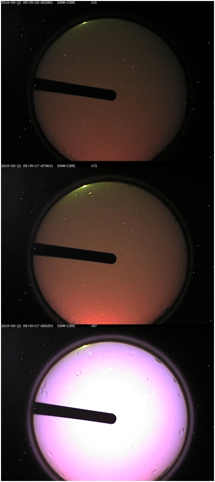
Figure 3; Sequence of images taken with the total-sky SONA camera, with the pinky brilliance corresponding to a lightning near the observatory (at 05:30 UTC).
In addition to these peculiar images, the episode left important amounts of precipitation: the automatic rain gauge of the Semiautomatic Surface Observation System (SOSS) gathered 45,4 mm from 00 UTC to 24 UTC on September 22. This amount surpassed the daily maximum precipitation record for a month of September within the 1971-2000 period. The rainiest day within that period for a month of September took place in 1984, with 35.8 mm on September 20. The past September 22 became also the rainiest day for this month since 1967. As it has been mentioned before, Tenerife and the rest of the western islands were affected by rains. Thus, at Mazo airport (La Palma Island) the record (44.7 mm) surpassed its historical record maximum for a month of September (the meteorological series started in 1970). Previous record was 40.0 mm on September 20, 1984.
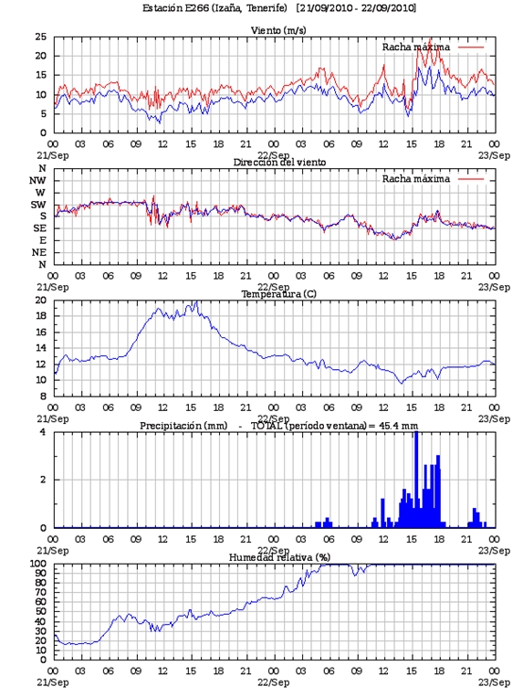
Figure 4; Meteorological 10-minute records (from upper panel to lower panel: wind speed, wind direction, temperature, precipitation and relative humidity) corresponding to September 21 and 22 at the Izana Atmospheric Observatory. Most of the precipitation was observed in the afternoon September 22, although some rain was recorded before, at early morning, when the electrical storm was observed.