August 2015 was the wettest since records began in Izaña
August 2015 has been very interesting from a meteorological point of view at the Izaña Atmospheric Observatory, located 2,373 meters above sea level on the island of Tenerife.
Temperatures averaging 16°C, have been more than 2°C below average of the reference period 1981-2010 at Izaña. This anomaly was more marked in the maximum temperatures (2,6ºC negative anomaly) than the minimum (1.9ºC negative anomaly). These values make August 2015 the third coldest year in a series of 100 years. We must go back to 1956 to find an August with lower average temperature.
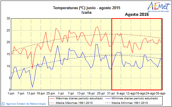
Maxima and minima daily temperatures at Izaña Observatory during summer 2015. August period is highlighted with a red box.
However, it is the rainfall pattern which has really been extraordinary this month: total accumulated precipitation was 87.3 mm (l/m2), thus becoming the wettest August in all the climatological series of the Izaña Observatory, well above the previous record of 56.6 mm corresponding to August 2005.
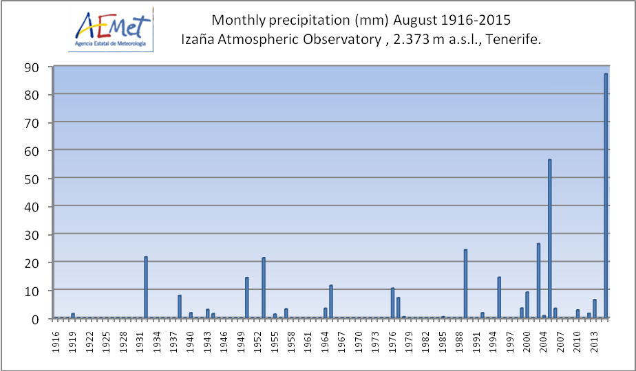
Monthly precipitation of August series at the Izana Atmospheric bservatory (1916-2015).
Should be noted that, as shown in the graph, in most years August is presented as a very dry month: in 70% of cases precipitation is zero, and the average precipitation for period 1981-2010 it is only 5 mm. Therefore it draws attention to the high amount recorded in 2015, up almost 17 times that average.
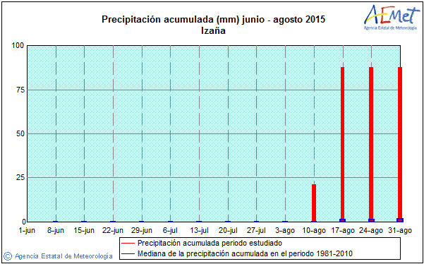
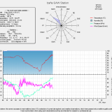
The Izaña precipitation during summer 2015: all the accumulated precipitation was recorded in the week from 10 to 17 August. A huge deviation is observed with respect to normal values, represented in this graph by the median.
Most of the precipitation of month was concentrated between August 13 and 14. On August 13, 49.4 mm were registered, equaling the daily record of maximum rainfall in 24 hours of August 2005. The rain had convective character, as moderate to heavy showers, with some moments of torrential intensity. Shortly after noon August 13, a heavy downpour and hail discharged with unusual force in the Observatory, accumulating 7 mm in just two minutes.
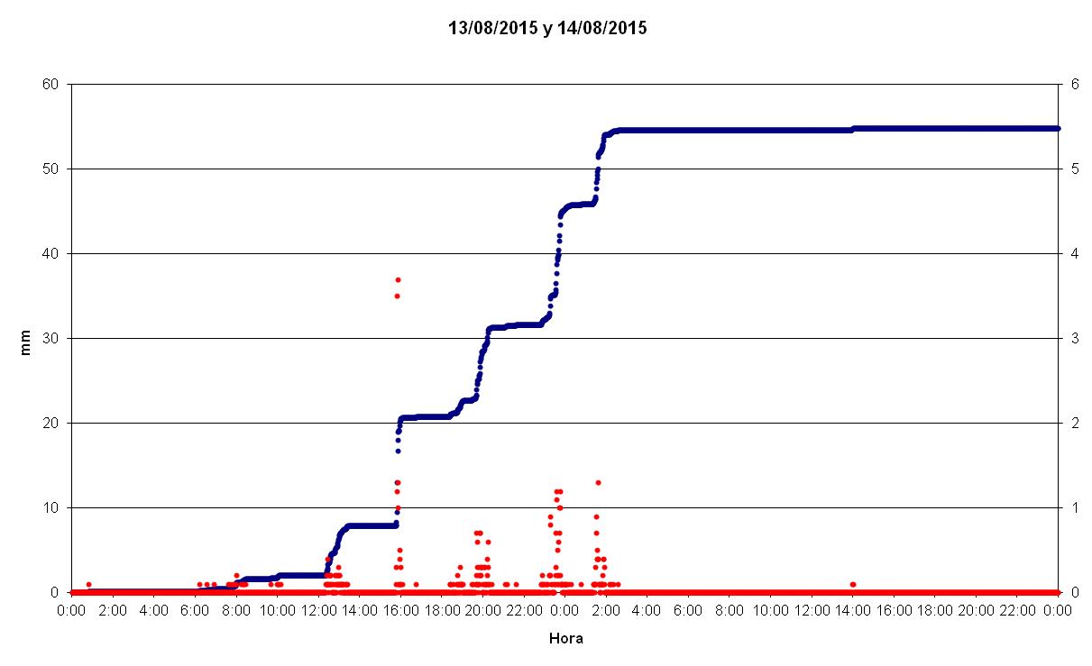
Accumulated precipitation at Izaña during August 13 and 14,t 2015. Red dots represent the moments in which precipitation was measured, and blue dots represent the accumulated precipitation. The stepped shape of the graph indicates that rain dropped mostly in the form of showers.
The following video, recorded by Conchy Bayo, GAW Technician at the Observatory, testifies to the strength of the rain in periods of greatest intensity of the storm:
There was also an unusually high storm activity for August: between 22: 00h on August 12 and 01: 00h of August 13 a total of 2,855 lightning strikes were recorded in the vicinity of the Canary Islands. The storms occurred, with less intensity, along the 13 August.
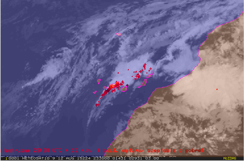
Map of lightning strikes corresponding to a 15-minute period after 23:00h on August 12, 2015: it draws attention the enormous number of lightning strikes in such a short period of time, affecting mainly the island of Tenerife.