The first moderate dust intrusion this summer on July 8
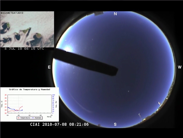
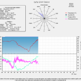
Last July 8 occurred the first moderate Saharan dust intrusion of this summer. It was detected by several sensors at the Izaña Atmospheric Observatory. Animated frames from the total sky SONA camera (5 minutes step) at the Izaña Observatory synchronized with 15-minutes natural RGB images (Channel 1 red, channel 2 green and channel 3 blue) of Meteosat-9 (upper left animation) for July 8, 2010 are shown. The movie shows very clearly a sharp change of color sky and visibility from 14 to 16 UTC due to the intrusion of a Saharan dust cloud. A very dense stratocumulus sea, associated to the trade wind regime, was quickly replaced by dust over the ocean. This intrusion was accompanied by a front of medium altocumulus type clouds, colored in blue, what is an indication of presence of ice crystals on their top which emit low radiation in the near infrared (channel 3 with inverted values). In the lower left animation, the evolution of temperature and relative humidity is displayed. The temperature at the Observatory rose very quickly with a peak of 26ºC.
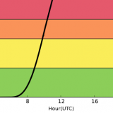
However, the presence of dust was detected a little bit earlier by sunphotometers. The PFR (Precision Filter Radiometer) recorded a sharp increase in aerosol optical depth at around 12 UTC (an increase of an order of magnitude in less than an hour) with a simultaneous reduction in the Angstrom Exponent (Alfa), which accounts for the size of the aerosols, indicating the presence of coarse mineral dust from the Sahara (Alfa<0.6).

{flv width=”800″ height=”640″ flashver=”0.0.0″ alt=”Error”}comp05{/flv}